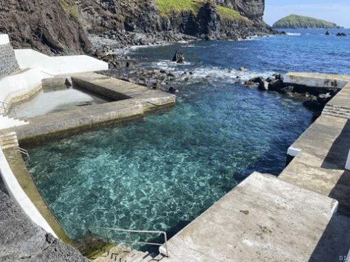
The temperature of the seawater in Graciosa reached a maximum of 28 degrees (celsius or 82.4 Fahrenheit) this week, which once again highlights a thermal anomaly phenomenon.
Eduardo Brito de Azevedo, professor of climatology at the University of the Azores (UAç), explains that “this sometimes happens, but towards the end of August”, which makes the “values, in fact, anomalous”.
“People wonder how it can be hotter in the north than in the south. There is a transport of warm water further north, through the Atlantic Gyre, which brings warm water from the Gulf Stream to more northerly latitudes. That’s why the waters usually warm up earlier in Flores and then Graciosa, etc.,” he says.
He adds that “at these latitudes, there is a zonal transport along the meridians, from west to east”.
This dynamic doesn’t mean that the temperatures seen in Graciosa will be felt in Terceira. “Not necessarily. It will depend a lot on how things evolve, things are already slightly changed,” says the UAç professor.
The researcher stresses that what happened in Graciosa “confirms, in a way, a climate change scenario, with a persistent water warming anomaly in the Atlantic”.
As Eduardo Brito de Azevedo explained to DI, since 2023 the waters have had an anomaly of around one and a half degrees higher than expected. “The thermal anomaly in the Atlantic is not just from this year, it has been progressive and consistent. We can already suspect, at least, that it’s due to climate change, especially something this big,” he said.
Last week, the IPMA (Portuguese Institute for the Sea and Atmosphere) forecast that the temperature would reach 26 degrees.
Specific aspects contributed to this rise. “Our anticyclone is to the southwest and is weaker than normal, which means it doesn’t generate enough wind to mix the surface water of the sea. The water is heated on the surface and is not mixed with deeper waters,” said Eduardo Brito de Azevedo at the time.
The transport of dust from the Sahara desert was also reduced, which led to a cleaner atmosphere and more energy from solar radiation. The retired professor from the Azorean university stressed, however, that this is a trend that has been consistent over the last few years.
In the short term, more storms can be expected with the presence of La Niña in the Pacific. “There is a relationship between the alternation of El Niño and La Niña. El Niño reduces storms in the Atlantic and La Niña increases storms in the Atlantic. These are relatively consistent studies, which means that if we combine the high temperature of the seawater, which is one of the reasons why tropical storms form, with the occurrence of La Nina, we could have a more intense hurricane season,” he said.
In the longer term, the balance of marine fauna and flora could be threatened. “We could be talking about a greater presence of gelatinous elements, such as jellyfish or caravels, etc. Then there’s the acidification of the oceans, which is a consequence of global warming. The ocean acquires a higher concentration of carbonic acid and, in more acidic conditions, gelatinous animals are more likely than animals that need carbon for their skeletons. So there is this tendency,” he said. Krill, at the base of the food chain, could be one of the elements affected.
in Diário Insular, José Lourenço – director
Translated to English as a community outreach program from the Portuguese Beyond Borders Institute (PBBI) and the Modern and Classical Languages and Literatures Department (MCLL) as part of Bruma Publication and ADMA (Azores-Diaspora Media Alliance) at California State University, Fresno, PBBI thanks Luso Financial for sponsoring NOVIDADES.